Land for sale in Land At Lower Road, Arrington, Royston SG8, £950,000
950,000.00
Offer Nr.:
65572149
Type of ad:
for Sale
Property type:
Land
Contact name:
Cheffins - Cambridge
Phone(s):
01223 784698
Email:
* Freehold
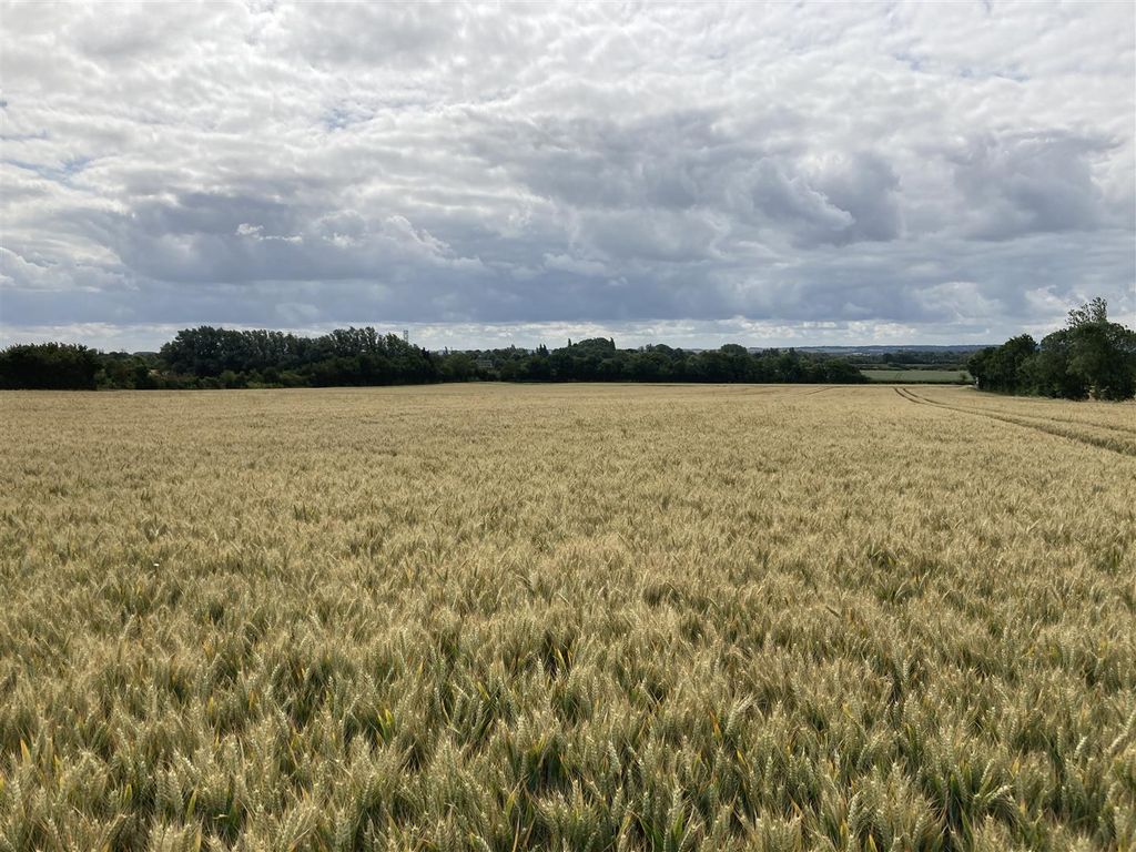
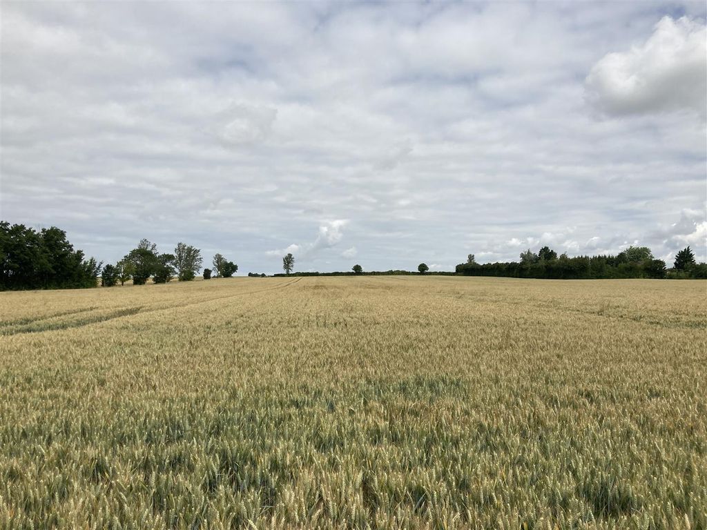
92. 03 acres (37. 24ha) of productive agricultural land in A prominent position
in south cambridgeshire with road frontage.
An excellent opportunity topurchase an attractive ring - fenced block of arable
land capable of producing combinable crops and sugar beet. The land is
situated in South Cambridgeshire however inclose proximity to the
Hertfordshire/Central Bedfordshire border and benefits from excellent
transport links.
The land is offered for sale with vacant possession oncompletion.
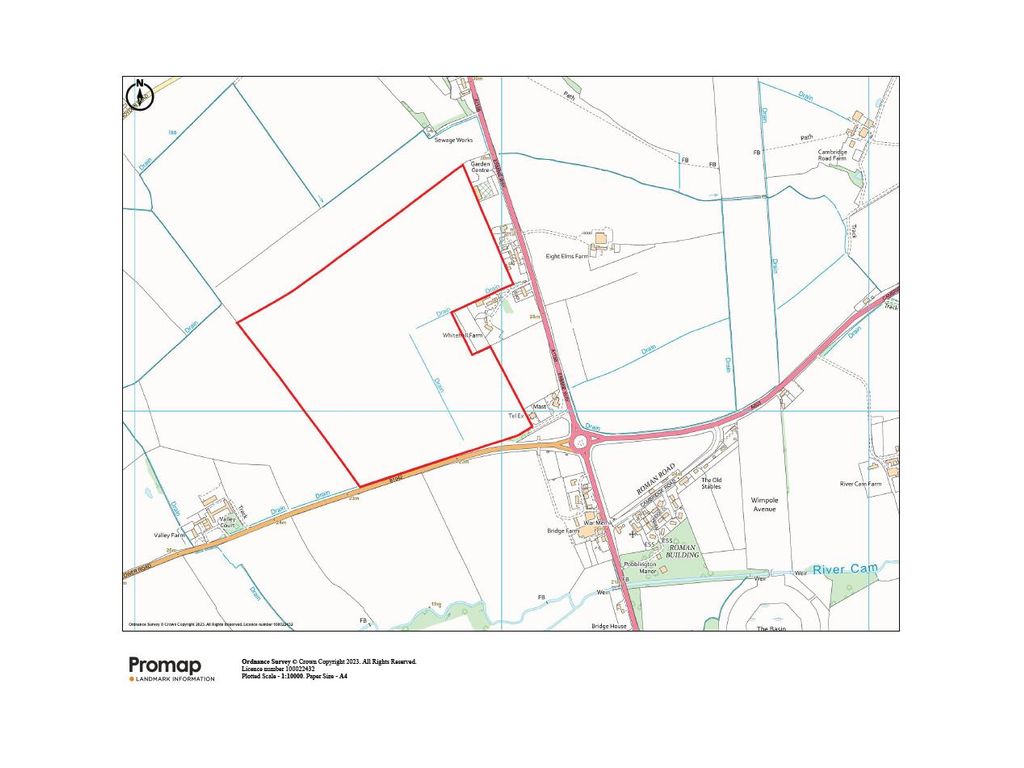
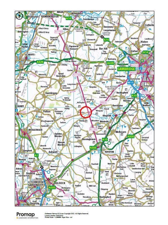
**Location**
The land is located approximately 1 mile south of the village of Arrington, 5
miles north of the town of Royston and the University City ofCambridge is
situated 10 miles to the north east. The land has road frontage onto the
B1042, via gated access and is in close proximity to the roundabout connecting
theA603 to Cambridge and A1198 to the north and south.
**Method Of Sale**
The land is offered for sale by private treaty as a whole.
**Description**
The land is gentlyundulating from north to south and contained within a ring -
fenced block. The land is naturally split into two parcels, separated by a
drain. The land is classified asGrade 3 and is of the Evesham 3 soil series
of slowly permeable calcareous clayey, and fine loamy over clayey soils. It is
in arable cultivation and farmed on a rotationof combinable crops and sugar
beet.
There are mature hedgerows and ditches defining the boundaries. The land
benefits from an additional right of access from the A1198via the bp Garage
at Arrington, running to the south of Arrington Telephone Exchange.
Land drainage has been installed where necessary and a regular programme of
moledrainage has been undertaken.
The cropping history can be found in the brochure.
**Development Overage**
The land will be sold subject to a Development Overage in theevent that
planning permission is granted for any development other than for agricultural
or equestrian purposes. The overage will not apply to carbon offsetting,
biodiversity net gain or other such land based or environmental schemes.
The uplift will be for 30% of any net development value resulting from the
grant of planningpermission, change of use or similar consent within a period
of 30 years from completion of the sale. The overage will be triggered on
commencement of the development oron the sale of the land with planning
permission whichever is sooner.
**Tenure And Possession**
The land is offered for sale with vacant possession oncompletion
**Drainage Rates**
Environment Agency drainage rates are currently payable at the standard rates
**Vat**
The land is registered for VAT.
**Town And CountryPlanning**
The land is situated within South Cambridgeshire District Council and is sold
subject to any development plans, tree preservation orders, townplanning
schedules, applications, permissions and resolutions which may be or come into
force. The purchaser(s) will be deemed to have full knowledge and have
satisfiedthemselves as to the provisions of any such matters affecting the
property.
**Basic Payment Scheme**
The land has been claimed for Basic Payment Scheme entitlements andis
registered on the Rural Land Register. The outgoing tenant will retain the
2023 bps payment and all historic delinked payments.
The purchaser(s) will be required toindemnify the outgoing tenant with regard
to any claim in respect of breach of cross compliance or any other relevant
scheme regulations for the current year up until 31December 2023.
**Environmental And Grant Schemes**
There are no environmental schemes on the land.
**Sporting, Timber And Minerals**
All sporting, timber and mineralrights are included in the sale insofar as
they are owned.
**Wayleaves, Easements, Covenants And Rights Of Way**
The land is sold subject to and with the benefit of allexisting wayleaves,
easements, covenants and rights of way whether or not disclosed.
**Tenant Rights And Dilapidations**
There will be no ingoing valuation and thepurchaser shall not claim for
dilapidations, if any, in relation to the property.
The land has not been drilled and will be left in its current state following
the 2023harvest.
**Exchange And Completion**
Exchange of contracts shall be within 6 weeks of the purchaser(s) solicitor
receiving a draft contract. Completion will be byagreement between the
parties.
**Boundaries**
The vendor and vendor’s agents will do their best to specify the ownership of
boundary hedges, fences and ditches butwill not be bound to determine these.
The property is available for inspection and the purchaser(s) will be deemed
to have satisfied themselves as to the ownership andlocation of the
boundaries.
**Plans, Areas And Schedules**
Plans attached to the particulars are based upon the Ordnance Survey and are
for identification purposes only.
**Local Authority**
South Cambridgeshire District Council South Cambridgeshire Hall, Cambourne
Business Park, Cambourne, Cambridge CB23 6EA
**Viewings And FurtherInformation**
The land can be viewed by prior arrangement with the Sole Agents. For further
information please contact Jonathan Purkiss or Simon Gooderham.Contact
details can be found in the brochure.
As always, potential hazards exist on working farms and it is requested that
all viewings are undertaken with care andregard to safety. Particularly with
regard to any areas in and around buildings.
Nearest Postcode: SG8 0AG
what3words: ///exhale. breeze. vanished
**Anti - MoneyLaundering Regulations**
Buyers will be required to provide proof of identity and address to the
Selling Agent following acceptance of an offer (subject to contract) andprior
to Solicitors being instructed.
**Agents Notes**
For clarification we wish to inform purchaser(s) that we have prepared these
sales particulars as a general guide.None of the statements contained in
these particulars as to the property shall be relied on as statements of fact.
All measurements are given as a guide and no liabilitycan be accepted for
errors arising therefrom. The plan and acreages use gross acreages taken from
the Ordnance Survey sheets and are for identification purposes only.The
purchaser(s) shall be deemed to have full knowledge of the state and condition
thereof and as to the ownership or any tree boundary or any part of the
property. Ifcommunications, condition of the property, situation or such
factors are of a particular importance to you please discuss these priorities
with us before arranging anappointment to view. This should avoid a wasted
journey. August 2023
92. 03 acres (37. 24ha) of productive agricultural land in A prominent position
in south cambridgeshire with road frontage.
An excellent opportunity to
land capable of producing combinable crops and sugar beet. The land is
situated in South Cambridgeshire however in
Hertfordshire/Central Bedfordshire border and benefits from excellent
transport links.
The land is offered for sale with vacant possession on
**Location**
The land is located approximately 1 mile south of the village of Arrington, 5
miles north of the town of Royston and the University City of
situated 10 miles to the north east. The land has road frontage onto the
B1042, via gated access and is in close proximity to the roundabout connecting
the
**Method Of Sale**
The land is offered for sale by private treaty as a whole.
**Description**
The land is gently
fenced block. The land is naturally split into two parcels, separated by a
drain. The land is classified as
of slowly permeable calcareous clayey, and fine loamy over clayey soils. It is
in arable cultivation and farmed on a rotation
beet.
There are mature hedgerows and ditches defining the boundaries. The land
benefits from an additional right of access from the A1198
at Arrington, running to the south of Arrington Telephone Exchange.
Land drainage has been installed where necessary and a regular programme of
mole
The cropping history can be found in the brochure.
**Development Overage**
The land will be sold subject to a Development Overage in the
planning permission is granted for any development other than for agricultural
or equestrian purposes. The overage will not apply to carbon offsetting,
biodiversity net gain or other such land based or environmental schemes.
The uplift will be for 30% of any net development value resulting from the
grant of planning
of 30 years from completion of the sale. The overage will be triggered on
commencement of the development or
permission whichever is sooner.
**Tenure And Possession**
The land is offered for sale with vacant possession on
**Drainage Rates**
Environment Agency drainage rates are currently payable at the standard rates
**Vat**
The land is registered for VAT.
**Town And Country
The land is situated within South Cambridgeshire District Council and is sold
subject to any development plans, tree preservation orders, town
schedules, applications, permissions and resolutions which may be or come into
force. The purchaser(s) will be deemed to have full knowledge and have
satisfied
property.
**Basic Payment Scheme**
The land has been claimed for Basic Payment Scheme entitlements and
registered on the Rural Land Register. The outgoing tenant will retain the
2023 bps payment and all historic delinked payments.
The purchaser(s) will be required to
to any claim in respect of breach of cross compliance or any other relevant
scheme regulations for the current year up until 31
**Environmental And Grant Schemes**
There are no environmental schemes on the land.
**Sporting, Timber And Minerals**
All sporting, timber and mineral
they are owned.
**Wayleaves, Easements, Covenants And Rights Of Way**
The land is sold subject to and with the benefit of all
easements, covenants and rights of way whether or not disclosed.
**Tenant Rights And Dilapidations**
There will be no ingoing valuation and the
dilapidations, if any, in relation to the property.
The land has not been drilled and will be left in its current state following
the 2023
**Exchange And Completion**
Exchange of contracts shall be within 6 weeks of the purchaser(s) solicitor
receiving a draft contract. Completion will be by
parties.
**Boundaries**
The vendor and vendor’s agents will do their best to specify the ownership of
boundary hedges, fences and ditches but
The property is available for inspection and the purchaser(s) will be deemed
to have satisfied themselves as to the ownership and
boundaries.
**Plans, Areas And Schedules**
Plans attached to the particulars are based upon the Ordnance Survey and are
for identification purposes only.
**Local Authority**
South Cambridgeshire District Council South Cambridgeshire Hall, Cambourne
Business Park, Cambourne, Cambridge CB23 6EA
**Viewings And Further
The land can be viewed by prior arrangement with the Sole Agents. For further
information please contact Jonathan Purkiss or Simon Gooderham.
details can be found in the brochure.
As always, potential hazards exist on working farms and it is requested that
all viewings are undertaken with care and
regard to any areas in and around buildings.
Nearest Postcode: SG8 0AG
what3words: ///exhale. breeze. vanished
**Anti - Money
Buyers will be required to provide proof of identity and address to the
Selling Agent following acceptance of an offer (subject to contract) and
to Solicitors being instructed.
**Agents Notes**
For clarification we wish to inform purchaser(s) that we have prepared these
sales particulars as a general guide.
these particulars as to the property shall be relied on as statements of fact.
All measurements are given as a guide and no liability
errors arising therefrom. The plan and acreages use gross acreages taken from
the Ordnance Survey sheets and are for identification purposes only.
purchaser(s) shall be deemed to have full knowledge of the state and condition
thereof and as to the ownership or any tree boundary or any part of the
property. If
factors are of a particular importance to you please discuss these priorities
with us before arranging an
journey. August 2023
Property location on the map: Use mouse double click to (Zoom IN: LEFT button; Zoom OUT: RIGHT button)