Land for sale in Grangewood, Swadlincote, Derbyshire DE12, £110,000
110,000.00
Offer Nr.:
64633196
Type of ad:
for Sale
Property type:
Land
Contact name:
Fisher German Ashby De La Zouch
Phone(s):
01530 658941
Email:
* Freehold
* Well positioned amenity land
* Recreational and conservation opportunities (subject to necessary consents)
* Pedestrian and vehicular access
* Easilyaccessible from Birmingham, Ashby de la Zouch, Swadlincote and Burton on Trent
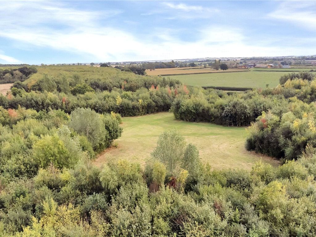
About 11. 02 acres (4. 46 hectares) of mixed woodland and pasture with road
frontage.
Description
Land at Grangewood comprises an attractive block of mixed broadleaf woodland
and level pastureland, well located just outside the popular village ofCoton
In The Elms. The woodland is formed of Ash, which makes up the majority of the
woodland and there is also oak, birch, willow and wild cherry. The woodlandis
divided by low maintenance rides and glades. The woodland forms part of a
30 - year National Forest Tender Scheme which began in 2006. The land totals
approximately27. 01 acres. The land benefits from multiple access points with
vehicular and pedestrian access off Coalpit Lane and a further vehicular
access along the easternboundary.
The land contains a naturally forming scrape which could be utilised to
establish a natural pond. The most landlocked Oak Tree in the UK as recognised
by theNational Forest Company is situated within Lot 3 and may be available
by separate negotiation. Please contact the selling agents for further
information.
Location
Theland is located in the rural hamlet of Grangewood, just 1. 3 miles from the
village of Coton in the Elms, South Derbyshire. The larger towns of Ashby de
la Zouch andSwadlincote are within easy reach providing a wide range of
amenities.
Overage
The land will be sold subject to an uplift provision which will specify that
25% of anyincrease in value due to development (as defined in Section 55 of
the Town and Country Planning Act 1990) will be payable to the Vendors or
their successors in titleshould such development occur within 40 years from
the date of completion. The uplift will be payable upon implementation or on a
future sale with the benefit of aplanning consent but shall not be triggered
by any development for agricultural and/ or non - commercial equestrian
purposes.
Services
There are no services currentlyconnected to the property. Prospective
purchasers should make their own independent enquiries as to connectivity.
Tenure
The freehold of the property is to be sold withvacant possession available
upon completion.
The property is offered for sale by private treaty as a whole or in lots. The
land is subject to a carbon sequestrationagreement which commenced in 2006
for a period of 99 years. The purchaser will be obligated to observe the terms
of this agreement. Further details are available from theselling agent.
Conditions of Sale
The purchaser will be required to take on the National Forest Contract for the
remainder of the scheme.
Local Authority
SouthDerbyshire District Council
Public Rights of Way, Wayleaves and Easements
The Property is sold subject to and with the benefit of all easements, quasi
easements,wayleaves and rights of way both declared and undeclared. Please
note that there is a section of a public footpath running across from the
westerly boundary of the land,as shown on the sale plan.
Plans and Boundaries
The plans within these particulars are based on Ordnance Survey data and
provided for reference only. They are believedto be correct, but accuracy is
not guaranteed. The purchaser shall be deemed to have full knowledge of all
boundaries and the extent of ownership. Neither the vendor northe vendor's
agents will be responsible for defining the boundaries or the ownership
thereof.
Viewings
Viewings of the land may be undertaken during daylight hours onlyand with a
copy of these particulars to hand. Viewers must confirm the time of their
inspection to the selling agent prior to arrival.
Telephone: Directions
Postcode –DE12 8DZ
what3words ///paves. limitless. backpacks
* Well positioned amenity land
* Recreational and conservation opportunities (subject to necessary consents)
* Pedestrian and vehicular access
* Easily
About 11. 02 acres (4. 46 hectares) of mixed woodland and pasture with road
frontage.
Description
Land at Grangewood comprises an attractive block of mixed broadleaf woodland
and level pastureland, well located just outside the popular village of
In The Elms. The woodland is formed of Ash, which makes up the majority of the
woodland and there is also oak, birch, willow and wild cherry. The woodland
divided by low maintenance rides and glades. The woodland forms part of a
30 - year National Forest Tender Scheme which began in 2006. The land totals
approximately
vehicular and pedestrian access off Coalpit Lane and a further vehicular
access along the eastern
The land contains a naturally forming scrape which could be utilised to
establish a natural pond. The most landlocked Oak Tree in the UK as recognised
by the
by separate negotiation. Please contact the selling agents for further
information.
Location
The
village of Coton in the Elms, South Derbyshire. The larger towns of Ashby de
la Zouch and
amenities.
Overage
The land will be sold subject to an uplift provision which will specify that
25% of any
the Town and Country Planning Act 1990) will be payable to the Vendors or
their successors in title
the date of completion. The uplift will be payable upon implementation or on a
future sale with the benefit of a
by any development for agricultural and/ or non - commercial equestrian
purposes.
Services
There are no services currently
purchasers should make their own independent enquiries as to connectivity.
Tenure
The freehold of the property is to be sold with
upon completion.
The property is offered for sale by private treaty as a whole or in lots. The
land is subject to a carbon sequestration
for a period of 99 years. The purchaser will be obligated to observe the terms
of this agreement. Further details are available from the
Conditions of Sale
The purchaser will be required to take on the National Forest Contract for the
remainder of the scheme.
Local Authority
South
Public Rights of Way, Wayleaves and Easements
The Property is sold subject to and with the benefit of all easements, quasi
easements,
note that there is a section of a public footpath running across from the
westerly boundary of the land,
Plans and Boundaries
The plans within these particulars are based on Ordnance Survey data and
provided for reference only. They are believed
not guaranteed. The purchaser shall be deemed to have full knowledge of all
boundaries and the extent of ownership. Neither the vendor nor
agents will be responsible for defining the boundaries or the ownership
thereof.
Viewings
Viewings of the land may be undertaken during daylight hours only
copy of these particulars to hand. Viewers must confirm the time of their
inspection to the selling agent prior to arrival.
Telephone: Directions
Postcode –
what3words ///paves. limitless. backpacks
Property location on the map: Use mouse double click to (Zoom IN: LEFT button; Zoom OUT: RIGHT button)
Similar properties: