Land for sale in Claypole, Newark, Lincolnshire NG23, £70,000
70,000.00
Offer Nr.:
65696222
Type of ad:
for Sale
Property type:
Land
Contact name:
Fisher German Ashby De La Zouch
Phone(s):
01530 658941
Email:
* Grade 3 arable land
* Suitable for a range of uses (subject to any consents)
* Close proximity to the A1
* For sale by private treaty
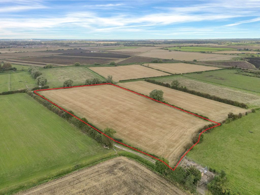
* Available as a whole or in up tosix lots
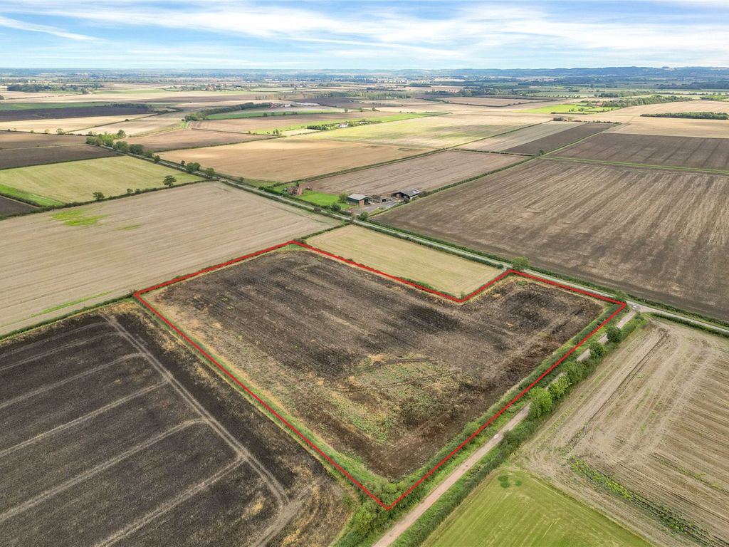
* Lot 4 - 8. 05 acres (3. 26 hectares)
8. 05 acres (3. 26 hectares) of agricultural land situated around the village of
Claypole, Nottinghamshire.
***Offers tobe submitted no later than 12 noon on 20th October
2023***
Situation
The land is situated around the village of Claypole approximately, 4. 9 miles
south east ofNewark, Nottinghamshire. Subdivided into 6 parcels, all the land
lies within 1. 5 miles of the village centre.
The A1 is located 2. 5 miles from the land, providing goodaccess up and down
the country.
Description
The land extends to 97. 47 acres (39. 46 hectares) or thereabouts and comprises
of six, relatively level parcels of varyingsizes. Classified as Grade 3 on
the Agricultural Land Classification, the soil is of the ‘Evesham 2’ series
and is suitable for cereals and grassland. All the land iscurrently in
stubble following this year’s harvest and the cropping history is shown below
(* denotes an area down to bird seed mix).
Lot 4 - 5179 (8. 05 acres 3. 26hectares)
2020/2021 Winter Wheat
2021/2022 Winter Wheat
2022/2023 Spring Beans
Method of Sale
The land is offered for sale as a whole by private treaty.
Tenure &Tenancies
The land is offered for sale with vacant possession on completion.
Services
Prospective Purchasers must satisfy themselves as to the availability of
servicesand any future connections.
Basic Payment Scheme
The Vendor have made a claim under the Basic Payment Scheme for the 2023 claim
year. The Purchasers will indemnify theVendors against any breaches of cross
compliance for the 2023 scheme year. As a result of the delinking of bps
payments from land use, the entitlements will not betransferred to the
incoming Purchasers.
Environmental Schemes
Lots 3, 5 & 6 are subject to a Countryside Stewardship - Mid Tier Agreement
which commenced on the 1stJanuary 2022 and expires 31st December 2026.
Public Rights of Way, Wayleaves and Easements
The land is sold subject to or with the benefit of all wayleaves, easements,
quasi - easements, rights of way, covenants and restrictions whether defined in
these particulars or not.
Nitrate Vulnerable Zone (nvz)
The Property lies within aSurface Water nvz Area and is subject to the usual
restrictions.
Drainage Rates
Drainage rates are payable to Upper Witham Internal Drainage Board. Further
details areavailable from the sole selling agents.
Sorting & Timber Rights
Sporting and timber rights in so far as they are owned are included within the
sale.
MineralRights
Mineral rights in so far as they are owned are included within the sale,
except where reserved by statue.
Boundaries
Prospective Purchasers will have to satisfythemselves as to the ownership of
boundaries.
**VAT**
Should any part of the sale or property become chargeable for the purpose of
VAT, then such tax will be payable bythe Purchaser(s).
Local Authority
South Kesteven District Council
Viewings
Unaccompanied viewing of the land to be conducted on foot during daylight
hours only, and whenin possession of these particulars. We would request that
you contact Fisher German prior viewing.
Directions
From the A1, leave the dual carriageway at the Balderton /Newark / Claypole
junction and follow the B6326 in a southerly direction towards Claypole.
Passing Barchester - Lancaster Grange Care Home on the right, follow theroad
for 0. 4 miles, then turn left on to Shire Lane and continue along this road
towards Claypole.
Please utilise What3Words for the location of each lot.
Lot 4 - NG235AS
What3Words: ///depending. rails. bashful
Health & Safety
For your own personal safety, we ask that you to take great care and be as
vigilant as possible when makingan inspection.
Plans, Areas & Measurements
The plans, photographs and measurements within the sales particulars are
provided for identification purposes only and do notform part of the sale
contract and the purchaser(s) shall be deemed to have fully satisfied
themselves as to the description of the property and neither the vendornor
the vendors agents will be responsible for defining the boundaries or the
ownership thereof.
* Suitable for a range of uses (subject to any consents)
* Close proximity to the A1
* For sale by private treaty
* Available as a whole or in up to
* Lot 4 - 8. 05 acres (3. 26 hectares)
8. 05 acres (3. 26 hectares) of agricultural land situated around the village of
Claypole, Nottinghamshire.
***Offers to
2023***
Situation
The land is situated around the village of Claypole approximately, 4. 9 miles
south east of
lies within 1. 5 miles of the village centre.
The A1 is located 2. 5 miles from the land, providing good
the country.
Description
The land extends to 97. 47 acres (39. 46 hectares) or thereabouts and comprises
of six, relatively level parcels of varying
the Agricultural Land Classification, the soil is of the ‘Evesham 2’ series
and is suitable for cereals and grassland. All the land is
stubble following this year’s harvest and the cropping history is shown below
(* denotes an area down to bird seed mix).
Lot 4 - 5179 (8. 05 acres 3. 26
2020/2021 Winter Wheat
2021/2022 Winter Wheat
2022/2023 Spring Beans
Method of Sale
The land is offered for sale as a whole by private treaty.
Tenure &
The land is offered for sale with vacant possession on completion.
Services
Prospective Purchasers must satisfy themselves as to the availability of
services
Basic Payment Scheme
The Vendor have made a claim under the Basic Payment Scheme for the 2023 claim
year. The Purchasers will indemnify the
compliance for the 2023 scheme year. As a result of the delinking of bps
payments from land use, the entitlements will not be
incoming Purchasers.
Environmental Schemes
Lots 3, 5 & 6 are subject to a Countryside Stewardship - Mid Tier Agreement
which commenced on the 1st
Public Rights of Way, Wayleaves and Easements
The land is sold subject to or with the benefit of all wayleaves, easements,
quasi - easements, rights of way, covenants and restrictions whether defined in
these particulars or not.
Nitrate Vulnerable Zone (nvz)
The Property lies within a
restrictions.
Drainage Rates
Drainage rates are payable to Upper Witham Internal Drainage Board. Further
details are
Sorting & Timber Rights
Sporting and timber rights in so far as they are owned are included within the
sale.
Mineral
Mineral rights in so far as they are owned are included within the sale,
except where reserved by statue.
Boundaries
Prospective Purchasers will have to satisfy
boundaries.
**VAT**
Should any part of the sale or property become chargeable for the purpose of
VAT, then such tax will be payable by
Local Authority
South Kesteven District Council
Viewings
Unaccompanied viewing of the land to be conducted on foot during daylight
hours only, and when
you contact Fisher German prior viewing.
Directions
From the A1, leave the dual carriageway at the Balderton /
junction and follow the B6326 in a southerly direction towards Claypole.
Passing Barchester - Lancaster Grange Care Home on the right, follow the
for 0. 4 miles, then turn left on to Shire Lane and continue along this road
towards Claypole.
Please utilise What3Words for the location of each lot.
Lot 4 - NG23
What3Words: ///depending. rails. bashful
Health & Safety
For your own personal safety, we ask that you to take great care and be as
vigilant as possible when making
Plans, Areas & Measurements
The plans, photographs and measurements within the sales particulars are
provided for identification purposes only and do not
contract and the purchaser(s) shall be deemed to have fully satisfied
themselves as to the description of the property and neither the vendor
the vendors agents will be responsible for defining the boundaries or the
ownership thereof.
Property location on the map: Use mouse double click to (Zoom IN: LEFT button; Zoom OUT: RIGHT button)